
GAGAN
About
- GAGAN (GPS Aided GEO Augmented Navigation) is an Indian Satellite Based Augmentation System (SBAS) over the Indian Region.
- SBAS is an air navigation system that improves the accuracy, integrity, and availability of Global Navigation Satellite Systems (GNSS) signals (like GPS).
- GAGAN is the first such system developed for India and neighboring countries in the equatorial region.
- It was developed by Indian Space Research Organisation (ISRO) and Airports Authority of India (AAI).
- Fully operationalized in 2015, the main objectives of GAGAN are:-
- To provide satellite-based navigation services with the accuracy and integrity required for civil aviation applications;
- To provide better Air Traffic Management over Indian Airspace.
Working
- GAGAN works by detecting GPS signal errors through ground stations and transmitting corrected navigation signals via geostationary satellites to provide more accurate positioning to aircraft.
- It operates through geostationary satellites such as GSAT-8, GSAT-10 to broadcast corrected navigation signals.

- The system is interoperable with other international SBAS systems like US-Wide Area Augmentation System (WAAS), European Geostationary Navigation Overlay Service (EGNOS), and Japanese MTSAT Satellite Augmentation System (MSAS), etc., and provides seamless navigation across regional boundaries.
Applications of GAGAN
- Although GAGAN was primarily developed to enhance aviation navigation and enable precise aircraft landing, its high-accuracy positioning services support several other sectors as well.
- These include safer maritime navigation, intelligent transport systems and vehicle tracking, accurate land surveying and mapping for infrastructure planning, and disaster management activities such as search-and-rescue operations.
Global Navigation Satellite System:
- GNSS includes global systems such as Global Positioning System (GPS) – United States, GLONASS – Russia, Galileo – European Union, and BeiDou – China.
Geostationary Earth Orbit (GEO):
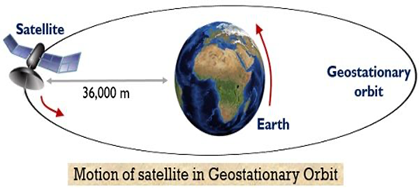
- In GEO, satellites orbit the Earth at the same speed as its rotation and appear fixed over one location, making them ideal for communication and navigation services.
- It is located about 36,000 km above the Earth.
Why in News?
- India has completed its first-ever GAGAN-based satellite-guided landing of a commercial aircraft.
- The milestone is significant because it showcases an alternative to the conventional Instrument Landing System (ILS), the precision landing aid installed at many major airports but absent at several smaller and secondary airports due to its high installation and maintenance costs.
- By enabling precision approaches through satellite guidance, the technology is expected to improve operational safety, especially at airports without ILS infrastructure.